 At the beginning of the 18th century, almost all of Sullivan County was secured by patents, including Hardenberg Patent (or Great Patent) (Quinlan 1873:9-11). Over time, these land holdings were sub-divided into Great Lots, which were in turn divided into smaller lots that were then sold off, but despite the land sales, the area remained only sparsely settled until after the Revolutionary War (Quinlan 1873: 11, 111-114). One of the impediments to settlement was the hostilities between the European settlers and the Native American population, who were at times under the sway of the French, and later the British.
Following the Revolutionary War, the construction of transportation networks, including the Newburgh-Cochecton Turnpike, which linked Newburgh and the Delaware River at Cochecton, encouraged movement into the area. The Newburgh-Cochecton Turnpike, chartered in 1801, was among the first in the state (Wakefield 1970:2-3). It was the brainchild of a group of Newburgh businessmen, who wished to see an increase in the flow of goods between their riverfront stores and the interior. Shortly after the establishment of the turnpike, the increase in population led to the formation of Sullivan County from Ulster County. Settlement focused on areas such as Bloomingburg, Monticello and Liberty, with smaller villages, such as Wurtsboro, growing up along the Delaware & Hudson Canal (referred to as the D & H Canal), which was chartered in 1823. In addition to the Newburgh-Cochecton Turnpike and the D & H Canal, which brought people and business to the area, there was also a lead mine and smelting facilities, as well as tanneries, a mainstay of the Catskill Mountain economy in the early years of the 19th century. The exploitation of the hemlock, used to tan the leather, led to a collapse of the tanning industry, but at the time of the Civil War it was boasted that over 80 percent of the boots and leather goods used by the Union Army were supplied from the tanneries of Sullivan County (Wakefield 1970:6). The construction of the railroads through Sullivan County, which began along the Delaware River in the 1840s and elsewhere in the 1860s and 1870s, doomed the turnpikes and canals. The railroad provided easy access to markets for many of the farming communities in the county, but it also provided the route by which tourists came to Sullivan County, generating the summer vacation industry that was the mainstay of the county’s economy for many years. The first of the railroads to reach central Sullivan County was the New York & Oswego Midland Railroad, which, upon its bankruptcy in 1880, was acquired by the New York, Ontario & Western Railroad, referred to locally as the “Old & Weary.”
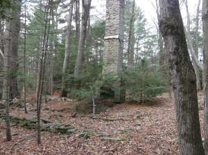
In the western portion of Forestburgh, there is an area that was historically known as Drakestown. Drakestown was settled by Zephaniah, Joseph, Adam, Nathan and Luther Drake, who had originally settled in coastal New Jersey. Joseph came in 1793 or 1794, with the others arriving during the next three years. Ira Drake, whose house was immediately west of the project area on the east bank of the Mongaup River, was a prominent member of his community, acting as a Justice of the Peace between 1837 and 1844. According to the local histories, the Drakes were hardy, industrious, worthy men who were respected at home and abroad. A. Drake owned a hotel to the east of the Mongaup River. To the north of the Drake hotel was a structure shown as belonging to the heirs of S. Drake, the wife of Zephaniah Drake. Child’s Directory lists Alonzo C. Drake as a resident of the Town of Forestburgh. Child’s Directory does not include a listing for the Drake Hotel, so it is likely that the hotel was established sometime between 1873 and 1875.
The Drake hotel remained standing until after 1911. The creation of the Rio Reservoir changed the patterns of traffic in the western portion of Forestburgh and it is likely that the Drake family went out of business. The changing of the economic environment, two wars and the progress of time has erased nearly all evidence of the Drake family hotel. Currently all that remains is a wooden placard nailed to a tree and stone ruins that identify the location of the hotel.

